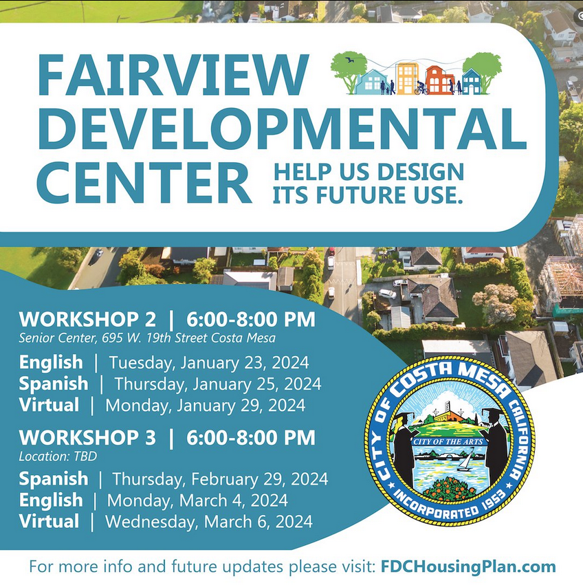
Last time around, I lamented that the public meeting about community “visioning” for Fairview Developmental Center probably didn’t matter. So what’s better than a pointless public meeting?
THREE pointless public meetings!
I kid, I kid. Kinda. I mean, look at the fruit this process has borne so far! Here is the draft “vision” statement — oh, sorry, I mean “guiding principles to support the Vision”, hot off the presses:
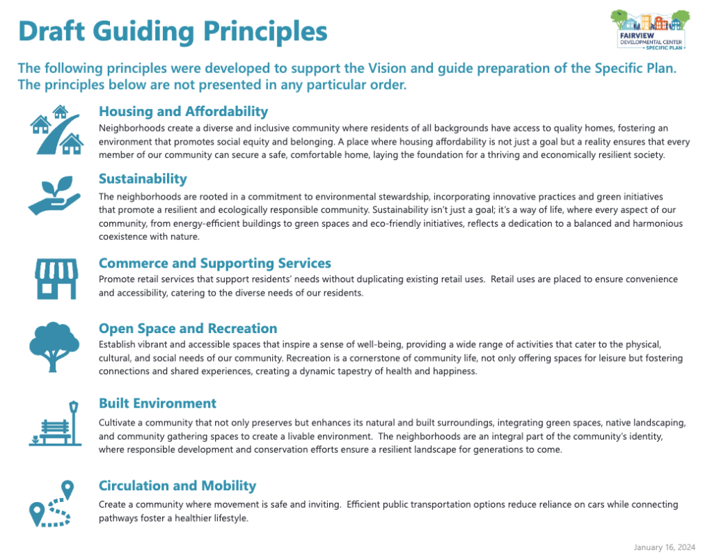
Now, I have no doubt that every leaf of that word salad above came out of the mouth or the pen of very earnest, very engaged residents that gamely attended the first FDC meeting and provided their comments in good faith. But here’s the problem with that: give human beings no guidance, no parameters and no limits, and they’ll fill whatever blank spot you give them with their dreams. Parroting back those limitless dreams is not the same thing as establishing “guiding principles”. I mean, based on the list above, the FDC property will not only solve affordable housing “for every member of our community” (?!?!) it will do so while being “resilient and ecologically responsible” (?!?!?!) and “creating a dynamic tapestry of health and happiness” (?!?!?!?!!!?!!!?!).
Dang. I’ll have whatever these FDC consultants are having.
But seriously, the one good thing that is coming out of this process is that it is long enough to give our particularly dogged residents opportunities to pry details out of the powers-that-be, and that’s helping to bring into focus the actual task in front of us when we’re discussing the FDC. Thanks to persistent haranguing from Cynthia McDonald, one of the folks behind Costa Mesa First, the City and its consultants quietly released the “Story Map” slideshow that will be presented at the meeting tonight. While most of it is pretty fluffy, there are a few slides worth pausing on.
What infrastructure exists already in Fairview Developmental Center?

Based on that text and the accompanying map, I’d say, not much. In fact, I think it’s reasonable to assume that there is no presently suitable infrastructure (other than roads) that we can leverage or retrofit for future development of any kind. That means that either the City or a developer is going to have to go in there and meticulously lay brand new water pipes, gas lines, electricity and data cables, sewers and drains, etc., as if it were an undeveloped greenfield. Which would be bad enough, except that the consultants are also suspiciously mum about what is there now. Clearly there are buildings and people lived and worked there for decades! They had to have had running water, sewer pipes, electricity, etc., right?
My guess is that all this infrastructure is there, but it is so out-of-date, so self-contained or so potentially toxic that we can’t use it. Which means that, not only is someone going to have to pay to put those necessary upgrades in, someone will first have to pay huge sums of money to take the old stuff out. How much? When? Who will be responsible? No one knows! Or more likely, no one is saying.
Then we come to this slide, which presents new information (or at least new information to me).
The Incredible Shrinking Project Area
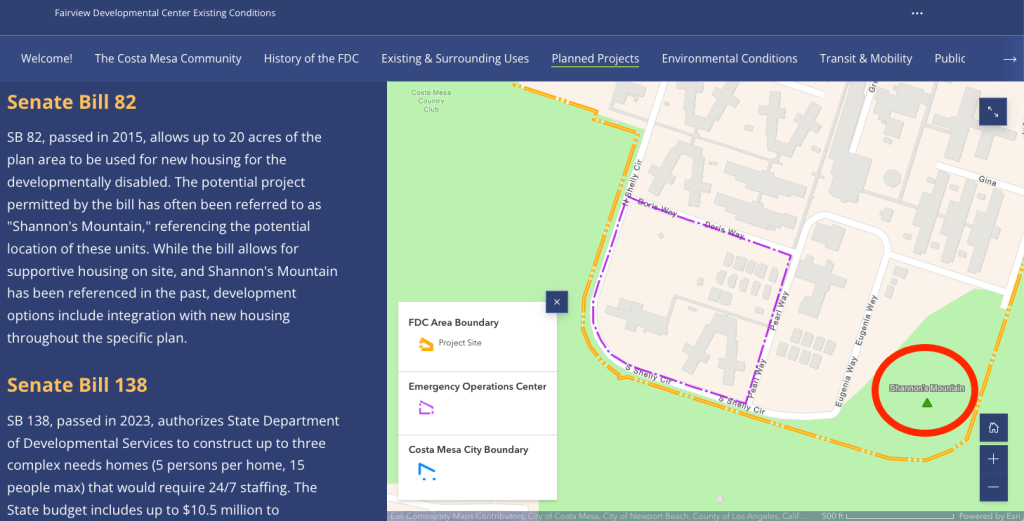
Most people following this project already knew that the area denoted in the dotted purple line was likely off-the-table when it comes to the larger development project, as the State had earmarked that corner as the future site of an Emergency Operations Center headquarters in the same process that saw the FDC site fall into Costa Mesa’s hands in the first place. However, I was not aware that the untouched open space in the Southeast corner of the FDC — circled in red above and labeled in tiny print as “Shannon’s Mountain” — was also spoken for thanks to 2015’s SB 82. It looks to me like SB 82 lops off another 20 acres of the project area, in addition to the 15 acres that was set aside for the EOC. This deal is getting worse all the time.
Transit Connections Look Bleak with No Hope in Sight

The StoryMap says there are three bus routes servicing the project area but really there are only two, as there are no bus lines that run on Tanager Drive to the North and no present access through the golf course to any of the bus lines that run on the streets to the South. Both of these lines are on Harbor Boulevard, which are cheerfully noted to stop a mere 225-320 feet away. But a quick check of Google Maps show that these short distances are measured from the edge of the project area closest to Harbor, meaning the realistic distance to those stops is likely to be much, much farther for most of the FDC’s future residents:

1,500 feet is right at the outer edge of where pedestrians feel comfortable walking to a transit stop on a regular basis. And that measurement is just as the crow flies to one stop going in one direction. What if you need to go South on Harbor Boulevard? Or go somewhere that Route 43 or the Bravo! bus doesn’t go?
It would be a bit more hopeful if we heard that OCTA was exploring options to bring more comprehensive service to the project area. But so far I haven’t heard anything of the sort.
So in summary: we’ve got guiding principles that say basically nothing, a StoryMap that casually lops off another 20 acres of the project area, and some hints that the infrastructure remediation and retrofitting will be a big and expensive project unto itself. Honestly, this is poised to get so complicated that I’m not sure this public meeting approach, by itself, is going to cut it. The City should look into a resident advisory committee for FDC and quickly. It’s going to need ambassadors that can absorb all this information and explain it, and I’m not sure our consultants are up to the task by themselves.

Leave a comment