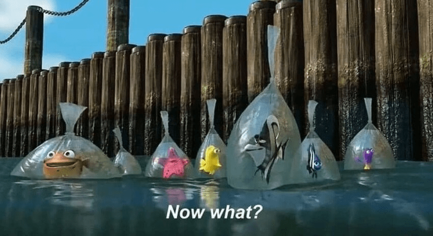
Around the midpoint of Pixar’s Finding Nemo (warning: minor spoilers follow), the main fish character finds himself temporarily taken in by a tank of fish that live in a local dentist’s office. All the tank fish want is to escape and return to the ocean. Their leader, a grizzled angel fish named Gill, has a bold plan escape while the fish are placed temporarily in plastic bags during their tank’s monthly cleaning.
By the end of the film, you find out that Gill’s plan eventually worked. Sorta:
Which brings us to, of all things, the Fairview Developmental Center Specific Plan draft. We’ve been planning for it for years at this point, with many public meetings, unending Planning Commission study sessions, and presentation after presentation to the City Council.
And yet, now that we have the full color, 300+ page result of all of that work, I’ll admit: I feel a bit like a fish in a plastic bag, floating along millimeters away from all of our goals, unable to figure out how to actually get there.
So, how should we think about the FDC Specific Plan Draft, and how do we even begin to “comment” on it?
There is a saying for these kinds of situations that goes something like, “how do you eat a whale?”, and the answer given is, “one bite at a time.” But frankly, eating a whole whale, even bit by bit, sounds awful. So I propose a more practical corollary: If you’ve been assigned to eat a whole whale, don’t, because that’s stupid. Eat the bits that appeal to you, and discard the rest.
So, step 1 to getting through this FDC Specific Plan Draft, let’s zero in on the bits that matter. Here’s what I would suggest to cut it down to size:
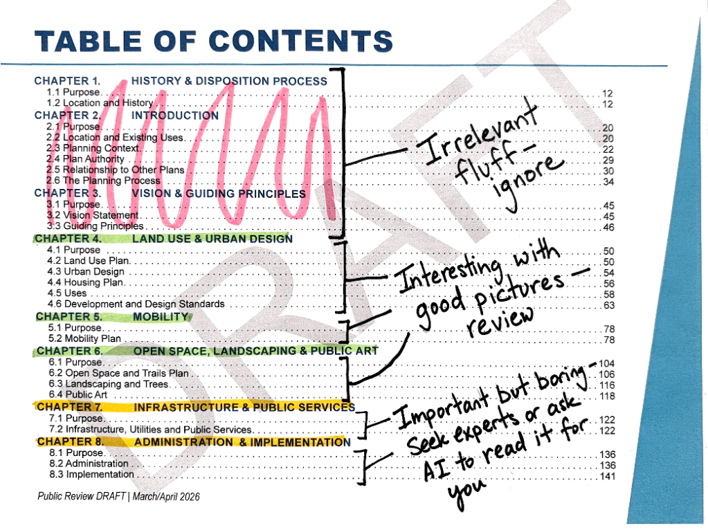
Ok maybe it’s a bit harsh to call the first 50 pages “fluff”, as I’m sure those pages represent many sleepless nights by city staff and consultants. But we’re in survival mode here so they’ve gotta go. So here’s what I would be thinking about as you review the pages that remain.
Land Use & Urban Design, Problem 1: Either Not Enough or Too Much Mixed Use
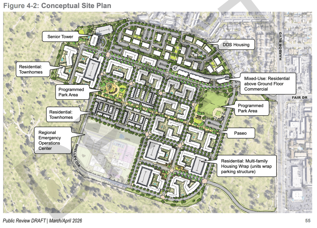
First up we have the Land Use & Urban Design chapter. The money shot of this section is the map we’re all pretty familiar with, which is a simplified version of “nobody wanted this” Concept 3 from the FDC planning meetings:
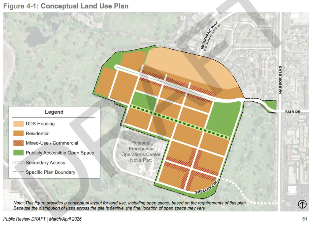
It’s hard to see from this picture, but that street grid is about as tight as the streets in the lower part of Eastside Costa Mesa. And my dog says that’s “pretty walkable”, so that’s good.
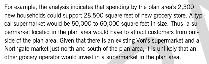
But that’s about where the “good” ends. Remember that the orange areas are supposed to fit four thousand units in them, so the scant amount of “mixed-use/commercial” seems like it is being asked to do far, far too much. Recall that this plan contemplates only 35,000 square feet of commercial space for the entire FDC site, which is about the same size as the “mini” Target on E. 17th Street. So that means there is almost no way a regular grocery store will fit in any of that hashmarked space.
Isn’t that a problem? Apparently not because, uh, the market analysis thinks everyone will drive to Northgate or Von’s. Which kinda blows a hole in the “pedestrian utopia” framing found elsewhere in the plan:
Another problem is that this small amount of commercial is not going to produce sufficient jobs to blunt the employment pressure that will be created by adding several thousand local job seekers. This is hinted out in the plan, which admits that the new population would support more than 75,000 square feet of new office and commercial space, which of course is far more than the plan calls for.
Finally, this “mixed use” space might have to also accommodate everything else in this plan that isn’t housing, including public or quasi-public buildings. The plan admits that it is very likely that both a new fire station and a new police substation will need to be located in the FDC area to maintain adequate public safety, but it doesn’t say where those things might go. If both housing and open space allotments are nonnegotiable, the only land use area left would be these “mixed use” districts. Another land use that is completely absent from the plan is places of worship. With churches, daycares, retail, restaurants, coffee shops, and even public services like police, fire and libraries competing for the same space, that 35,000 square feet could go quick.
… or it might not. Another problem with the commercial space in the plan is that it is all planned to be tucked-under, ground-floor retail. Ground-floor retail is intended to evoke some old European romanticism. Look at all those happy little pedestrians!
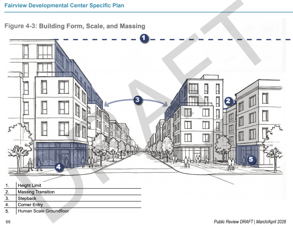
Unfortunately, the “human scale groundfloor” in that image, which I love from an aesthetic perspective, has been an absolute loser in the market. Consider, for example, the Google Maps screenshot of the Aliso Apartments in Downtown Los Angeles below. I strolled through here one afternoon looking for a bite to eat with my family before a Dodgers game. What do you notice about the ground-floor retail in this development’s “pedestrian paseo”?
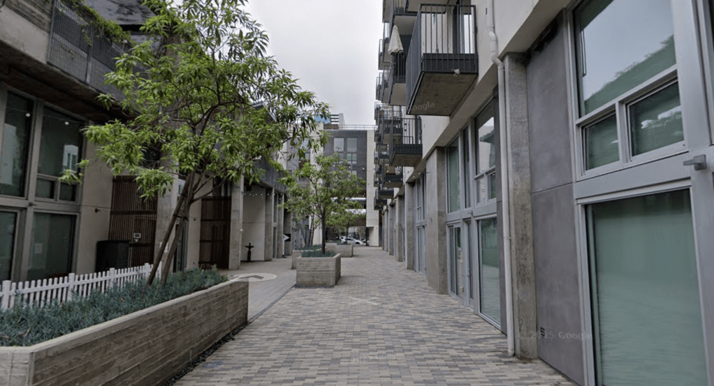
The Aliso Apartments opened for leasing in 2019. This photo is dated to September 2024. Nearly all of the groundfloor retail sits empty. This article from SFGate explains some of the reason why: brick-and-mortar retail demand is secularly down post-COVID, and many of these kinds of places — even with upper floor apartments — simply do not generate sufficient pedestrian foot traffic to support rents high enough to justify locking in tenants for 10, 15 years. This is such a big problem that many of these mixed use developers are looking for ways to convert these retail stalls into more housing units.
So locking the scant 35,000 square feet of commercial space into no-win ground-floor retail stalls seems like a bad idea.
Land Use & Urban Design, Problem 2: Where Are the Parks?
There is another fundamental problem with the land use plan, too, which is that it simply doesn’t provide enough open space to accommodate the needs of the new local residents, let alone start to make up for the broader city’s existing park space deficiencies. The City’s General Plan states that city policy should aim to achieve at least 4.26 acres of open space per 1,000 residents. If the FDC site ultimately houses 8,000 new residents — a conservative estimate of only 2 people per household multiplied by the planned 4,000 units — the plan should include a minimum of 34 acres of open space to accord with the General Plan’s guidelines.
Regrettably, the plan only anticipates 14 acres of open space, less than half of the General Plan’s goals. In other words, instead of backfilling Costa Mesa’s dire need for more publicly accessible open space, this plan actually makes the deficit worse.
Mobility, Problem 1: How Do We Move 8,000 People In and Out in Cars?
Ok, so the land use plan has some problems. How are the streets?
Honestly, not great. As discussed above, the plan is already assuming that most of the development’s residents will commute outside the FDC area for work/worship and for basic retail like groceries. Flip to the back of the plan and you’ll see that there are no specific plans for on-site schools, either, meaning all the students will likely commute by car as well (more on that in a moment).
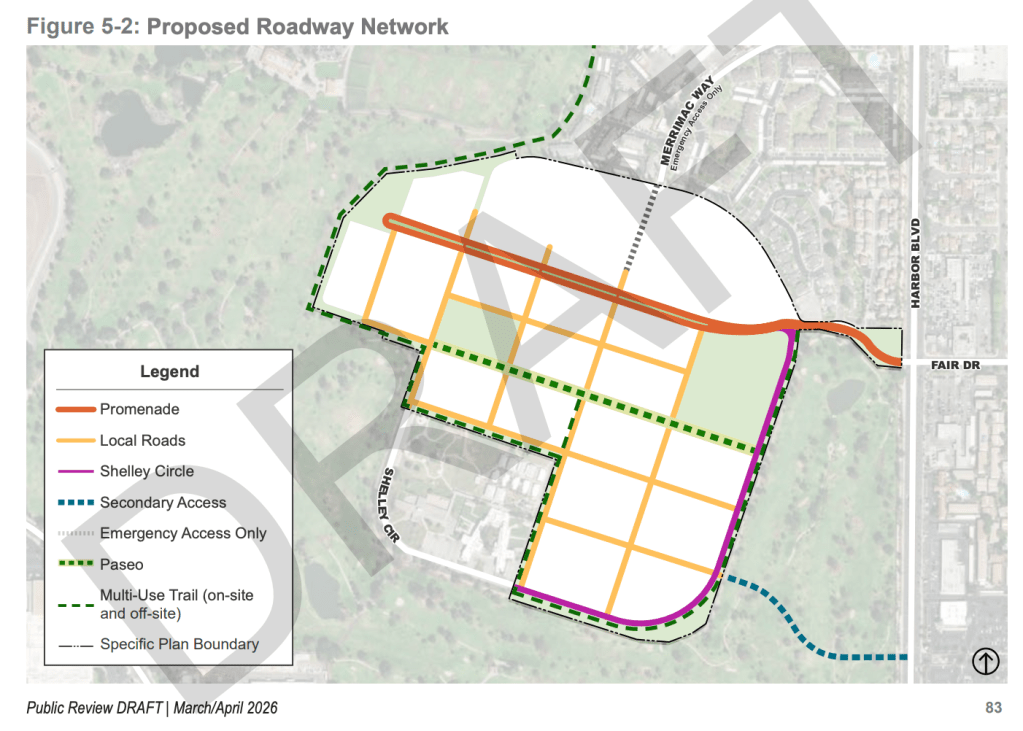
So, despite explicitly claiming that this is a “pedestrian-first development”, this plan implicitly requires a ton of car travel in and out of this area. And, despite that expectation, we are still only planning for two entrances and exits: the existing road at Fair Drive off of Harbor Boulevard, and the new mystery golf course road (erroneously labeled as a “multi-use trail” in the graphic above) that will peel off the southeast corner of the development. Merrimac Way remains “emergency access only”.
Yeah, that’s just not enough. Look closely at the cross-sections of both of these roads and you’ll see they are planned to be only one lane in either direction. That means that, if one of these roads is closed — due to a disaster, maintenance, accident, or otherwise — the entire development is going to be served by a single traffic lane. And, shockingly, this approach isn’t backed up by a single study, calculation or other metric analysis. Search “level of service” or “vehicle miles traveled” and you’ll find nothing specific to the FDC site.
Mobility, Problem 2: How Do We Move Anyone, Anywhere Not in a Car?
I noted in the land use section that the street grid isn’t bad in terms of walkability. And look, the cross-sections provided in the plan look great — they include lots of walking and bicycling paths, with bicycle commuting clearly prioritized in the street design.
But once again, the plan makes a lot of fuss about the walkability/bikeability of streets without providing places for these people to go. Nobody who is commuting on foot or by bike intends to simply go around in circles.
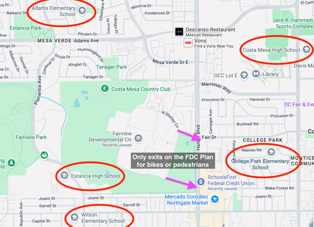
The school problem here seems especially egregious. The only reference to schools appears on page 132 of the plan, and it says literally nothing about running a study to analyze the impact of all these new students or to determine if a new school site would be necessary. Without a local school, kids are going to have to commute to existing ones. How exactly are they expected to do that, when the only exits strand them at one of Costa Mesa’s busiest roads, and far from their schools?
As we have learned from the unending conversations about e-bikes, if you don’t plan for student mobility, you aren’t planning for active transportation mobility at all.
At the very least, walkers and bicyclists should be allowed to cut across the golf course to get to Fairview Park, Estancia High School and Wilson Elementary without having to run the Harbor Boulevard gauntlet and going miles out of their way. But that leads us to yet another problem.
Mobility, Problem 3: Uh, What Happens to the Golf Course?
If you were hoping for some absolution regarding the fate of the Costa Mesa Golf Course in this plan, well, you aren’t getting it. The plan states clearly that the secondary access road through the golf course’s existing holes will be required for any plan contemplating more than 2,300 units. It then refers readers to Chapter 8 for more details… except the only detail provided in that chapter is that the master developer will be responsible for planning and paying for the road and any necessary golf course reconfiguration, without any further detail.
Will the master developer need to maintain the existing number of holes? Who knows. Recall that the golf course generates almost $4 million in annual revenue for the city. Will the developer need to deliver a reconfigured golf course that is economically viable? Doesn’t say. These aren’t trivial considerations. The lack of detail on what will become of the golf course seems pretty egregious.
Open Space, Landscaping and Public Art, Problem 1: Again, Not Enough
Almost all of the park-related problems in this section are downstream of the fact there is fundamentally not enough park space in the plan to go around. But a serious issue I have that is somewhat separate is that the plan seems to afford a remarkable amount of flexibility to the master developer over what goes into the little park space the plan does accommodate.
For example, this section makes repeated references to “paseos,” which are pedestrian walkways between buildings that accommodate vehicles only in emergencies. Though the plan doesn’t come out and say this, do the paseos count as public open space? If they do, then a master developer could litter the residential areas with these “paseos” and rid itself of the burden of building large parks.
As for the parks themselves, the plan doesn’t require the master developer to deliver anything specific. Sure, the plan says, the master developer could build playing fields, basketball courts, playgrounds, community gardens, etc. Unfortunately it doesn’t say it has to build any of those things. So if you’re looking at the picture below and expecting that the plan requires the master developer to build a baseball field in the western area and a playground in the eastern area, well, you’re mistaken. Those are just options. It could deliver nothing of the sort.
Open Space, Landscaping and Public Art, Problem 2: It Calls Back to the Parks Master Plan, Which… Is Bad
Ah, the intrepid planners might say, though: the plan does say that anything the master developer does on the FDC site has to accord with the city’s Parks Master Plan!
But that doesn’t get us anywhere, because the city’s Parks Master Plan isn’t, at least at the moment, worth the paper its written on. It was last formally updated in 2002, and while there was an abortive effort to update it in 2018, certain controversies (including the proposal to place ball fields in Fairview Park) contributed to that draft never being finalized.
The Rest: Infrastructure, Public Services, Administration and Implementation
I won’t bore you with slogging through these sections detail by detail, so I’ll just give you a few quick hits. This section probably benefits from you dropping the pages into an AI to analyze, as it requires a bit of background knowledge and/or familiarity with legal jargon to follow. But here are some bullets from my quick review if you are curious:
- Infrastructure: weakly analyzed. Southern California Edison says that we have enough power and natural gas resources to service the FDC, but that all of the on-site connection infrastructure will need to be completely torn out and replaced. How much does that cost? No one knows. And over in the water section, we get a scary bit of bright pink, bracketed text that says that a “water study is forthcoming”. The storm drain section similarly says that studies will be required to determine the needs there. But at least the sanitary district did its homework: it says it will need 6,100 linear feet of sewer pipes to be installed, which is a crazy expensive proposition. Who pays, and how much? Again, we’re left to speculate.
- Public Services: concerning. Apparently the Costa Mesa Police Department and the Costa Mesa Fire Department have flagged that local substations for each service will likely be required to maintain adequate public safety coverage. As we know from prior station rebuilds, those projects aren’t cheap, and the current plan doesn’t have anywhere specific for them to go. And as I’ve flagged above, there simply is no analysis of the educational needs of these new residents.
- Administration: full of jargon. This section goes over all of the technical and legal requirements of the site and the master developer. It’s not that it’s not important, but it’s tough to analyze for a broad audience. So just put a pin in this one.
- Implementation: materially deficient. There is at least one, giant, gaping hole in the implementation section, which not only goes over in broad strokes how all of this will be paid for but also the sequencing of construction. The development impact fees for all of this are… not defined?
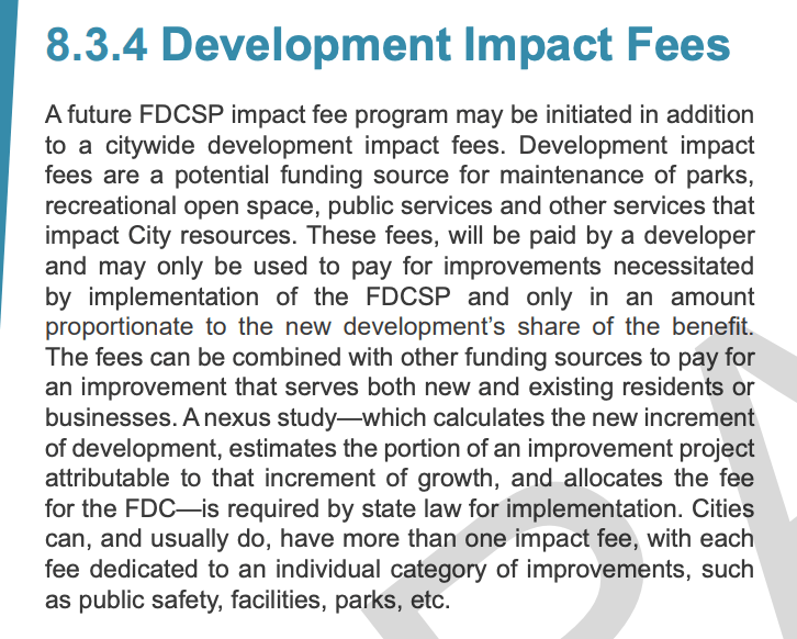
“… A future FDCSP impact fee program may be initiated in addition to a citywide development impact fees” (emphasis mine)? Grammatical problems aside, the plan’s treatment of development impact fees is simply inadequate for a project of this scale. The use of ‘may be initiated’ rather than ‘shall be established’ creates no binding commitment to fee collection. The plan does not identify fee categories, a timeline for nexus study completion, a responsible party for commissioning the study, or existing citywide fees the project will be subject to.
The failure to identify the party responsible for commissioning the nexus study is a particularly big miss. The nexus study determines how big the impacts are and thus how costly the impact fees will be. The master developer will have every incentive to minimize the extent of those impacts. So, shouldn’t the plan at least specify that the nexus study will be controlled either by the city or an impartial third party?
That’s all the whale I can eat. I’m full.

Leave a reply to leecefam Cancel reply